Malaysia is a beautiful country – but only if you avoid the traffic and don’t get lost! Here are the eight best maps of Malaysia to help you get around, and to help you learn about the country’s past and present:
1. Political Map of Malaysia
Image credit: www.malaysiamap.facts.co
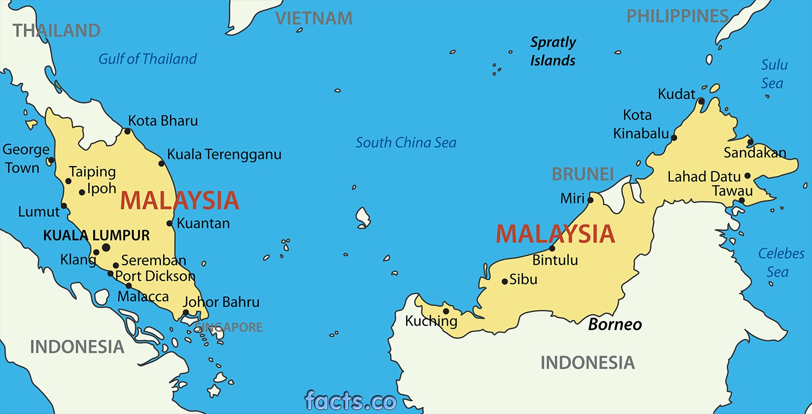
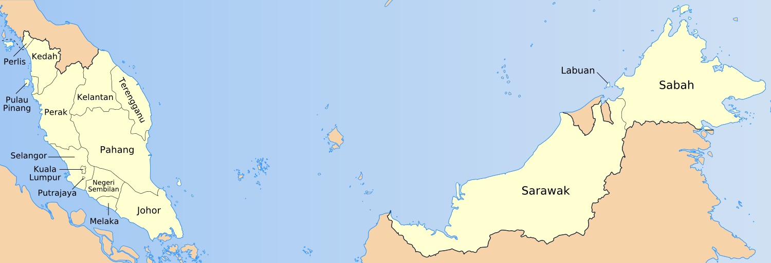
Malaysia is separated into two main landmasses: Peninsular Malaysia and East Malaysia (or Malaysian Borneo). The capital city is Kuala Lumpur and the government is seated in Putrajaya, both in the southern half of Peninsular Malaysia.
The country is separated into thirteen states: Kuala Lumpur, Labuan and Putrajaya (all Federal Territories), plus Johor, Kedah, Kelantan, Malacca, Negeri Sembilan, Pahang, Perak, Perlis, Penang, Sabah and Sarawak (the only two in East Malaysia), Selangor and Terengganu.
2. Highway Map of Malaysia
Image credit: www.saomaitours.com
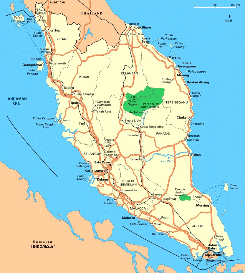
The country’s main road is the North-South Expressway, which runs from Bukit Kayu Hitam near the Thai border, to Johor Bahru near Singapore, and is nearly 800km (500 miles) long. It is also known as Federal Route 1.
Federal Route 2 runs from Kuala Lumpur to Kuantan in the east, where it intersects with Federal Route 3, which connects Johor Bahru to Kota Bahru, in the northeast corner of Malaysia.
Other important roads in Malaysia have been incorporated into the Asian Highway Network, which connects the whole continent. Key routes include: the AH140 from Butterworth to Gerik; the AH141 from Klang Valley to Kota Bharu, the AH142 from Yong Peng South to Gambang; and the AH150 along the Pan-Borneo Expressway.
See Also: Great Road Trips in Malaysia
3. Railway Map of Malaysia
Image credit: http://www.seacitymaps.com
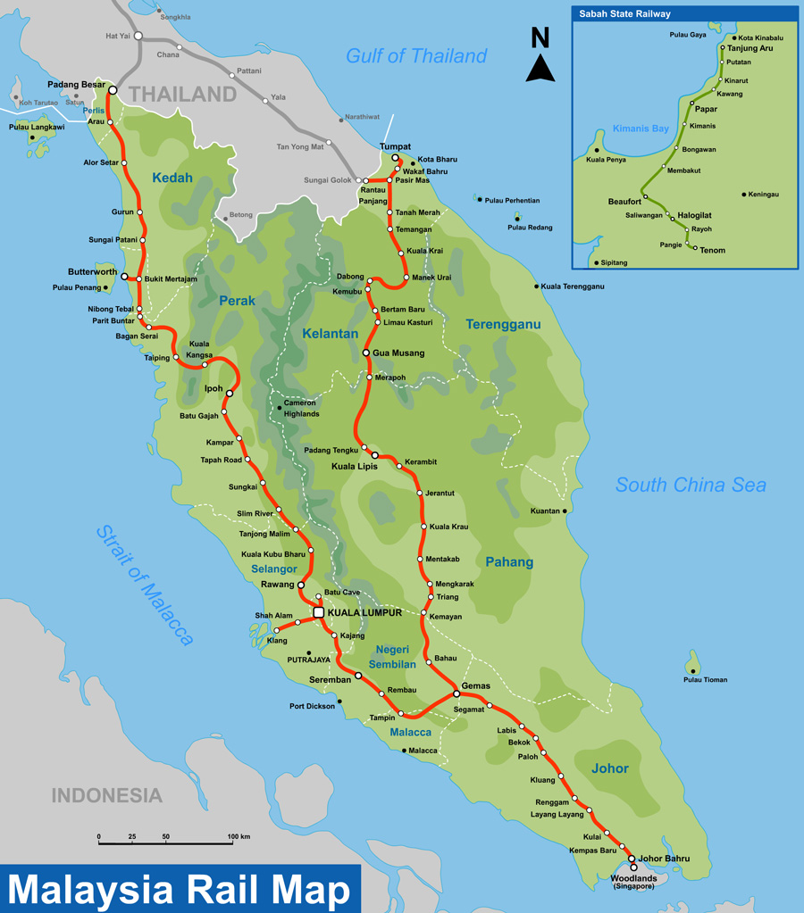
The main train station for Malaysia is at KL Sentral; this is where many of the county’s rail services arrive and depart, including the KLIA Transit and KLIA Ekspres services to the international and domestic airports.
11 states in Peninsular Malaysia are connected by rail, most of them by the two main lines, the KTM West Coast Line between Singapore and Padang Besar in Perlis near the Thai border, and the KTM East Coast Line, running from Gemas in Negeri Sembilan to Tumpat in Kelantan.
Curiously, the ‘Coast Lines’ don’t actually run alongside the shore; the East Coast Line instead passes through deep jungle, earning the nickname ‘the Jungle Railway’.
Smaller branches also serve Port Klang, Batu Caves, Butterworth, Teluk Intan, and Rantau Panjang via Pasir Mas. For an enjoyable change in tack, Penang has the country’s only funicular train line; the cable car rail system runs top the top of Penang Hill for great views out over the countryside.
See Also: Transportation Transformation in Kuala Lumpur
4. Klang Valley Rail Map and LRT in Kuala Lumpur
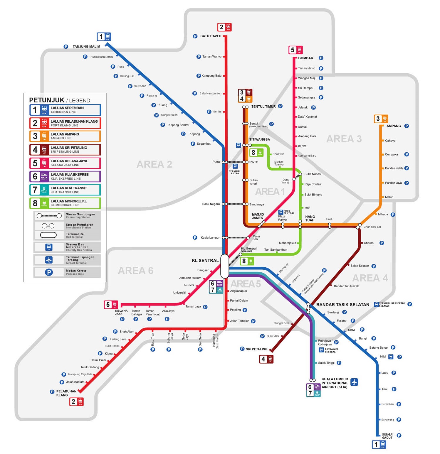
Zooming in on the capital a little further, Kuala Lumpur city centre has a dedicated monorail and light rail transit (LTR) lines. The Ampang line connects the terminals Sentul Timur in the north with Ampang in the east and Putra Heights in the south, running through three main intersections with other lines, at Masjid Jamek, Hang Tuah and Bandar Tasik Selatan.
The Kelana-Jaya line runs between Gombak in the north and Putra Heights in the south, and the monorail (‘Monorel’) connects Titiwangsa and KL Sentral.
The commuter (‘Komuter’) lines stretch out into the suburbs and beyond, connecting KL Sentral station to the Batu Caves, Seremban city in Negeri Sembilan, Tanjung Malim town in the state of Perak and Port Klang on the east coast.
5. Google Map of Malaysia
Image credit: www.maps.google.com
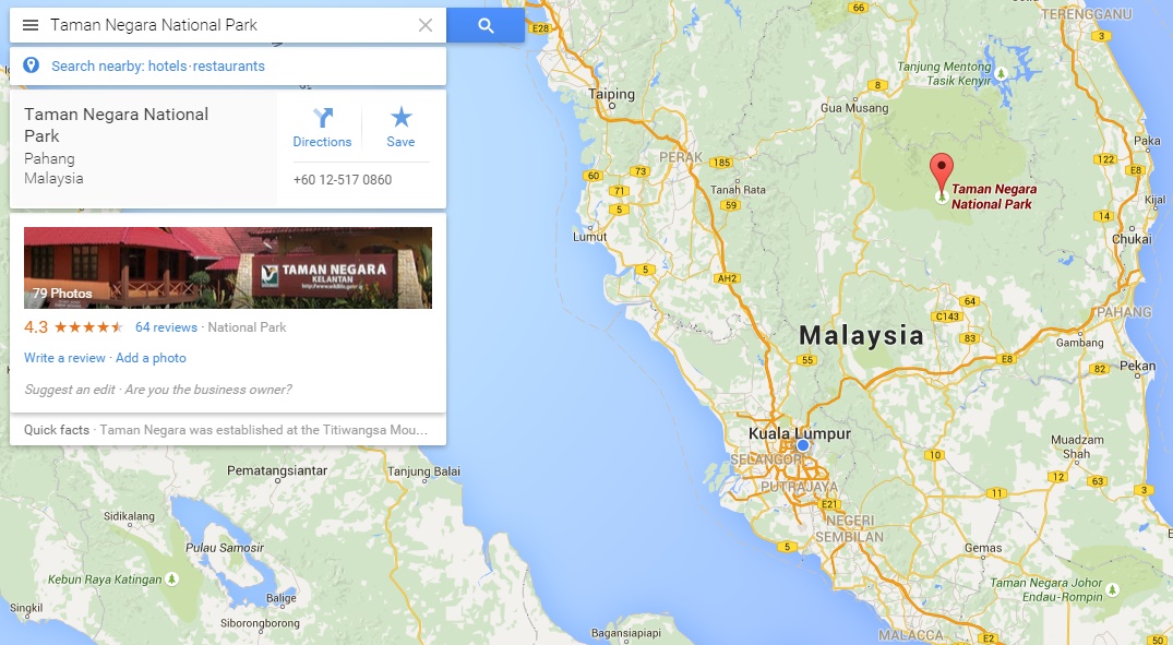
As is only fitting for one of the most popular apps and websites in the world, it would only make sense to include Google Maps.
Here are some key Malaysian GPS coordinates for you to get started: the entrance of Pavilion in Kuala Lumpur: (3.148263, 101.712955); the entrance to 1 Utama mall in Petaling Jaya: (3.147075, 101.614892); the Genting Highlands resort: (3.4232647, 101.792668) and the Taman Negara national park: (4.3720581, 102.433308).
For those without a mobile data connection, a really useful – and quite unknown – tip to keep your map available when you lose Wi-Fi signal is to first download the map of the area you want (via Wi-Fi), and then type ‘ok maps’ into the search bar. Google will download the map for you, so you still have functionality to zoom in and out of the map without needing data!
6. Most Popular Tourist Attractions Map of Malaysia
Image credit: www.pacifictourism.net
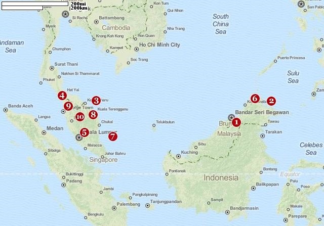
Malaysia has a huge diversity of types of tourist attraction, from natural to man-made, hilltop to shoreline. This map has handily compiled the destination of the top 10 destinations, and they as are follows:
10. Cameron Highlands, a hill station built by the British, popular for walking and its tea plantations; 9. George Town, the colonial city in Penang that’s world-famous for food and culture; 8. Taman Negara national park, one of the oldest tropical rainforests in the world; 7. Pulau Tioman, the paradise island with coral reefs; 6. Mount Kinabalu, the 4,095 metre-high mountain in Borneo, known worldwide for its endemic flora and fauna; 5. Petronas Twin Towers, the world’s tallest building until 2004; 4. Pulau Langkawi, home to white sand beaches and some of the best hotels and resorts in the country; 3. Perhentian Islands, the backpacker paradise with amazing dive facilities; 2. Sepilok Rehabilitation Centre, one of the best sites in the world to see orang-utans in their natural habitat; and 1. Mulu Caves, in Borneo, containing the Sarawak chamber – the largest cave chamber in the world.
See Also: Malaysia’s Top 10 Tourist Attractions
7. Waterfalls Map of Malaysia
Image credit: www.waterfallsofmalaysia.com
As well as purpose-built tourist attractions, Malaysia has stunning natural scenery, which can often be free to visit and explore. It has a great number of waterfalls, some of which can be reached from Kuala Lumpur in less than an hour.
The website waterfallsofmalaysia.com has painstakingly compiled the location of over 180 waterfalls in Peninsular and East Malaysia and given each of them a rating on accessibility, and a short description of the type of fall – such as cascade, single fall or multiple fall – and a list of activities available at the destination.
There is also a forum where guests can update the listings, or document any new locations they find.
See Also: 3 Waterfalls You Should Visit in Malaysia
8. Historical Map of Malaysia
British Malaya
Malayan Union
Independence day. Image credits: www.wikipedia.org, www.althistory.wikia.com
In 2015, Malaysia celebrates its 58th year of independence from the British Empire –‘Merdeka Square’ in KL is named after the Malaysian word for freedom.
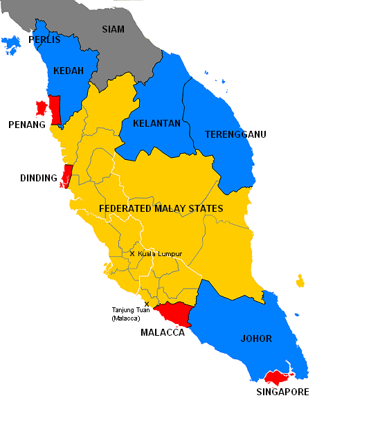
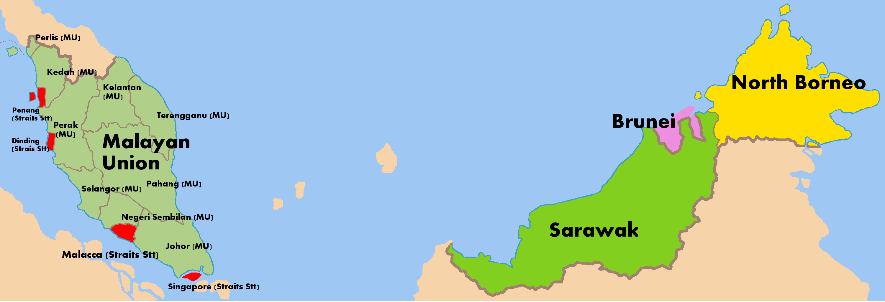
At the start of the 1900s, the peninsular region was separated into the Federated Malay States, the Unfederated Malay States and the British Straits Settlements. After World War One, the Malayan Union was formed, then replaced with the Federation of Malaya in 1948.
After independence in 1957, this country combined with Sarawak, North Borneo and Singapore in 1963 and took on the name ‘Malaysia’ as we know today. However, due to racial and political tension, Singapore was expelled from the Federation of Malaya and became independent in 1965 – 50 years ago this year.
Read This: A Photo Essay on Traveling Around the World and Malaysia
"ExpatGo welcomes and encourages comments, input, and divergent opinions. However, we kindly request that you use suitable language in your comments, and refrain from any sort of personal attack, hate speech, or disparaging rhetoric. Comments not in line with this are subject to removal from the site. "











Selamat Pagi